Your reference is clearly incomplete and selective. The erosion of the Lake Missoula floods were in loess (wind blown silt) and unconsolidated glacial sediments, and the Grand Canyon was cut through sandstone, limestone, basalt and metamorphic rock. The following is the most current research as follows:
Missoula Floods - Wikipedia
In 2000, a team led by Komatsu simulated the floods numerically with a 3-dimensional hydraulic model. They based the Glacial Lake Missoula discharge rate on the rate predicted for the
Spokane Valley–
Rathdrum Prairie immediately downstream of
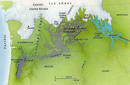
Glacial Lake Missoula, for which a number of previous estimates had placed the maximum discharge of 17 × 106m3/s and total amount of water discharged equal to the maximum estimated volume of Lake Missoula (2184 km3). Neglecting erosion effects, their simulated water flow was based on modern-day topography. Their major findings were that the calculated depth of water in each flooded location except for the Spokane Valley–Rathdrum Prairie was shallower than the field evidence showed. For example, their calculated water depth at the Pasco Basin–Wallula Gap transition zone is about 190 m, significantly less than the 280–300 m flood depth indicated by high-water marks. They concluded that a flood of ~106m3/s could not have made the observed high-water marks.
[15]
In comment on the Komatsu analysis, Atwater’s team observed that there is substantial evidence for multiple large floods, including evidence of mud cracks and animal burrows in lower layers which were filled by sediment from later floods. Further, evidence for multiple flood flows up side arms of Glacial Lake Columbia spread over many centuries have been found. They also pointed out that the discharge point from Lake Columbia varied with time, originally flowing across the Waterville Plateau into Moses Coulee but later, when the Okanagon lobe blocked that route, eroding the Grand Coulee to discharge there as a substantially lower outlet. The Komatsu analysis does not evaluate the impact of the considerable erosion observed in this basin during the flood (or floods) – hence the assumption that the flood hydraulics can be modeled using modern-day topography is an area which warrants further consideration – earlier narrower constrictions at places such as Wallula Gap and through the Columbia Gorge could be expected to produce higher flow resistance and correspondingly higher floods.
[16]
The current understanding
The dating for Waitt's proposed separation of layers into sequential floods has been supported by subsequent
paleomagnetism studies, which supports a 30–40 year interval between depositions of Mount St. Helens’ ash, and hence flood events, but do not preclude an up to 60 year interval.
[10] Offshore deposits on the bed of the Pacific at the mouth of the Columbia River include 120 meters of material deposited over a several thousand-year period that corresponds to the period of multiple scabland floods seen in the Touchet Beds. Based on Waitt's identification of 40 floods, this would give an average separation between floods of 50 years.
[17]
")