• Welcome to Religious Forums, a friendly forum to discuss all religions in a friendly surrounding.

    Your voice is missing! You will need to register to get access to the following site features:
    • Reply to discussions and create your own threads.
    • Our modern chat room. No add-ons or extensions required, just login and start chatting!
    • Access to private conversations with other members.

    We hope to see you as a part of our community soon!

is it cherry-picking or careful reading? how can a faith be based on an old book?

Socratic Berean

Occasional thinker, perpetual seeker
Hello,

I began my religious journey in christianity but lately I find that I cannot trust the bible so much anymore. Some of it is clearly false because science has disproven it, for example Noah's Flood. Other things are genuinely cruel and do not seem to reflect a loving Creator, such as the wars in the bible.

Other christians tell me what I do would be cherry-picking. IE, I take the good things from God but not what does not appeal to me. But how could I justify war and terror? The ancients were surely inventive about that and often in the bible there is no love but only subordination and attempts to be loyal to this scary God it speaks about.

But consider that, if I read any other book, I normally find something to like in it and something I do not like. When I read Lord of the Rings I enjoy reading about Frodo's courage and his friendship to Gandalf. But I do not like Saruman the White One and do not have to worship him. Why would I make Frodo and Saruman do the same ugly things? Frodo is good and Saruman is evil.

But in the bible I am told about a terroristic God who wants to be known as the God of love. Does not necessity tell me to accept a loving God and not a scary God?
Great topics for discussion, Trablano! Given that we are talking about a collection of 66 books, written by at least 40 authors on 3 continents over a period of circa 2,000 years, can we narrow the discussion a little, for the sake of clarity? Other than the narrative of the flood and wars, which book(s) are you having concerns about? Which wars or depictions of war are you referring to?
 

Kenny

Face to face with my Father
Premium Member
There is simply not enough water on the planet's surface and in the atmosphere, to cover all the land masses. A global flood is therefore totally impossible.
IF the topography of today is the same as it was before.
 

BilliardsBall

Veteran Member
Sarcasm noted. I do not believe the claim of trablano was 'reveal all,' except that appears to your claim.

My point was not made in sarcasm. Careful study helps those Bible scholars little who despise the author--this same bias would hamper the study of any book, of course.
 

shunyadragon

shunyadragon
Premium Member
IF the topography of today is the same as it was before.

IF . . . wow!

There is no objective verifiable evidence that the topography of the earth has changed significantly in over 10,000 years. The only change has been the melting of the ice age glaciers that has raised the sea level by measurable incremental degrees over the past 10,000 years. There is evidence of gradual erosion and deposition over that time. We have continuous uniform deposition of seasonal lake varves going back more than 10,000 years in a number of locations on earth.

Can you provide any objective verifiable evidence that there has been any significant change?
 
Last edited:

Kenny

Face to face with my Father
Premium Member
IF . . . wow!

There is objective verifiable evidence that the topography of the earth has changed significantly in over 10,000 years. The only change has been the melting of the ice age glaciers that has raised the sea level by measurable incremental degrees over the past 10,000 years. There is evidence of gradual erosion and deposition over that time. We have continuous uniform deposition of seasonal lake varves going back more than 10,000 years in a number of locations on earth.

Can you provide any objective verifiable evidence that there has been any significant change?
You haven't answered the Grand Canyon question and you are already jumping on another?
 

shunyadragon

shunyadragon
Premium Member
You haven't answered the Grand Canyon question and you are already jumping on another?

What is the problem with the Grand Canyon?

The different deltas over the history of the Grand Canyon have been located, and the evidence of the gradual erosion over time of the canyon is over whelming including periods of volcanic deposition. Based on the gravel, rocks and boulders through out the canyon, the erosion of the canyon is gradual over millions of years cutting through solid rock of sandstone, limestone and metamorphic rock. There is a still a meandering river pattern in terrain reflecting the original ancient river.

The history of the delta deposition of the Colorado River is described here:

So Where Did All The Dirt Go?

As a geologist and geomorphologist I have been on geology tours that have covered in detail the history of the Grand Canyon and associated series of deltas.

'dejavu' I believe we have been here before and I gave geologic academic references describing the history of the Colorado River Deltas.

So, what is the problem?????

Again . . . Can you provide any objective verifiable evidence that there has been any significant change in the last 10,000 years concerning the topography of the world?

Actually the Grand Canyon is your problem. First, you cannot explain the volcanic deposits in the canyon that have been eroded over millions of years, you know, hard volcanic rock.
 
Last edited:

Kenny

Face to face with my Father
Premium Member
What is the problem with the Grand Canyon?

The different deltas over the history of the Grand Canyon have been located, and the evidence of the gradual erosion over time of the canyon is over whelming including periods of volcanic deposition. Based on the gravel, rocks and boulders through out the canyon, the erosion of the canyon is gradual over millions of years cutting through solid rock of sandstone, limestone and metamorphic rock. There is a still a meandering river pattern in terrain reflecting the original ancient river.

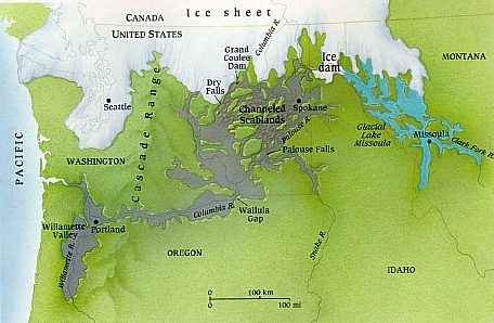
And yet in 24-48 hours a flood, by Lake Missoula (Eastern Washington), cut a canyon 300 - 900 feet deep.

IN JUST 2 DAYS--so you can imagine what 40 days and 40 nights can accomplish.

So we can look at the Grand Canyon and actually have two different opinion. Gravel, rocks and boulders can be older as well as newer and still moved by a single flood of 40 days and night and the same time because it is cutting through ground of different ages.
 

shunyadragon

shunyadragon
Premium Member
And yet in 24-48 hours a flood, by Lake Missoula (Eastern Washington), cut a canyon 300 - 900 feet deep.

IN JUST 2 DAYS--so you can imagine what 40 days and 40 nights can accomplish.

Different type of Glacial event. and Missouli canyon was created by multiple events over a period of 2000 years, and by far most of the erosion was loess (windblown silt) and glacial sediments. These floods did not cut through sandstone, limestone, volcanic basalt and metamorphic rock like the Grand Canyon. There is no comparison between the Missouli canyon and vast volume, size and extent of the Grand Canyon, and the nature of material removed.

So we can look at the Grand Canyon and actually have two different opinion. Gravel, rocks and boulders can be older as well as newer and still moved by a single flood of 40 days and night and the same time because it is cutting through ground of different ages.

Actually no, there are not any different opinions in the peer reviewed academic literature on the Grand Canyon. There is incremental evidence of the gradual erosion of the Grand Canyon including a volcanic even that created basalt flows and the progressive erosion continued. All the stages including the formation of the different Deltas and courses of the Colorado River are well documented with Geologic evidence.

The gravel and boulders can be identified with the individual formations they weathered originated from.

Opinions are not published in science journals, only sound documented geologic research.
 
Last edited:

Socratic Berean

Occasional thinker, perpetual seeker
There is simply not enough water on the planet's surface and in the atmosphere, to cover all the land masses. A global flood is therefore totally impossible.
The conversation gets more interesting when you add in ground water and, separately, water that is currently trapped within the very chemical matrix of rock deep below the earth's surface, which--according to studies by geophysicists at Northwestern University--may be equal, or even larger, in volume than the amount of water in the oceans. Were the account of the flood true, the existence of this underground water brings some clarity to the account in Genesis of "springs deep within the earth" erupting as a major contributor to the flood waters.
 

shunyadragon

shunyadragon
Premium Member
The conversation gets more interesting when you add in ground water and, separately, water that is currently trapped within the very chemical matrix of rock deep below the earth's surface, which--according to studies by geophysicists at Northwestern University--may be equal, or even larger, in volume than the amount of water in the oceans. Were the account of the flood true, the existence of this underground water brings some clarity to the account in Genesis of "springs deep within the earth" erupting as a major contributor to the flood waters.

No clarity at all, because this water currently trapped within the earth always has always been permanently trapped, and not available for the mythical flood.

This water is not the same groundwater we pump out of the ground to drink and irrigate crops. This water is a part of the surface hydrologic cycle.
 

Kenny

Face to face with my Father
Premium Member
Different type of Glacial event. and Missouli canyon was created by multiple events over a period of time. These floods did not cut through volcanic basalt and metamorphic rock like the Grand Canyon. There is no comparison between the Missouli canyon and vast volume, size and extent of the Grand Canyon
As we look at the same evidence and come to a different conclusion, I disagree.

As well as your position of "created by multiple events over a period of time"

"Water from Lake Missoula burst through the base of the dam, at a rate of ten times the combined flow of all the rivers in the world! Calculated flood speeds reached almost 65 miles per hour. At this rate, the lake would have drained in only a couple of days....

...When Lake Missoula was filled, waves along the shore eroded away at the surrounding mountains. Paleoshorelines are carved out of the hillside just outside of Missoula, Montana. The highest shorelines are found at 4200 feet elevation, which would drown the city of Missoula underneath approximately 2000 feet of water.

The flood waters of Lake Missoula also created giant gravel ripple-marks on the Camas Prairie in northwestern Montana. These ripple marks are found on the bottom of what was once Glacial Lake Missoula. These ripple marks are almost 50 feet high and have a wavelength of almost 500 feet. Ripple marks of such gigantic proportions could only have been made by incredibly powerful currents over the lake bottom."


Digital Geology of Idaho - Lake Missoula Floods


If anything, you have just proven my point that the banter goes on and on. Here you give one position and I provide evidence of another.

As I said, to be redundant, people can look at the same evidence and come to different conclusions.
 

Corvus

Feathered eyeball connoisseur
The conversation gets more interesting when you add in ground water and, separately, water that is currently trapped within the very chemical matrix of rock deep below the earth's surface, which--according to studies by geophysicists at Northwestern University--may be equal, or even larger, in volume than the amount of water in the oceans. Were the account of the flood true, the existence of this underground water brings some clarity to the account in Genesis of "springs deep within the earth" erupting as a major contributor to the flood waters.


Hard to believe.

Firstly the water bound into the crystalline matrix of the rock mantle while considerable in quantity is unavailable in free liquid form. Secondly, there is no natural mechanism to release that water in deluges, from the rock crystals, molecules of water are locked in, other than by thermally melting it. Thirdly it is between 5 - 70 Km deep to the first mantle layers. The oceanic crust is thinner.
 
Last edited:

shunyadragon

shunyadragon
Premium Member
As we look at the same evidence and come to a different conclusion, I disagree.

As well as your position of "created by multiple events over a period of time"

"Water from Lake Missoula burst through the base of the dam, at a rate of ten times the combined flow of all the rivers in the world! Calculated flood speeds reached almost 65 miles per hour. At this rate, the lake would have drained in only a couple of days."


Digital Geology of Idaho - Lake Missoula Floods


If anything, you have just proven my point that the banter goes on and on. Here you give one position and I provide evidence of another.

As I said, to be redundant, people can look at the same evidence and come to different conclusions.

Your reference is clearly incomplete and selective. The erosion of the Lake Missoula floods were in loess (wind blown silt) and unconsolidated glacial sediments, and the Grand Canyon was cut through sandstone, limestone, basalt and metamorphic rock. The following is the most current research as follows:

Missoula Floods - Wikipedia

In 2000, a team led by Komatsu simulated the floods numerically with a 3-dimensional hydraulic model. They based the Glacial Lake Missoula discharge rate on the rate predicted for the Spokane ValleyRathdrum Prairie immediately downstream of Glacial Lake Missoula, for which a number of previous estimates had placed the maximum discharge of 17 × 106m3/s and total amount of water discharged equal to the maximum estimated volume of Lake Missoula (2184 km3). Neglecting erosion effects, their simulated water flow was based on modern-day topography. Their major findings were that the calculated depth of water in each flooded location except for the Spokane Valley–Rathdrum Prairie was shallower than the field evidence showed. For example, their calculated water depth at the Pasco Basin–Wallula Gap transition zone is about 190 m, significantly less than the 280–300 m flood depth indicated by high-water marks. They concluded that a flood of ~106m3/s could not have made the observed high-water marks.[15]

In comment on the Komatsu analysis, Atwater’s team observed that there is substantial evidence for multiple large floods, including evidence of mud cracks and animal burrows in lower layers which were filled by sediment from later floods. Further, evidence for multiple flood flows up side arms of Glacial Lake Columbia spread over many centuries have been found. They also pointed out that the discharge point from Lake Columbia varied with time, originally flowing across the Waterville Plateau into Moses Coulee but later, when the Okanagon lobe blocked that route, eroding the Grand Coulee to discharge there as a substantially lower outlet. The Komatsu analysis does not evaluate the impact of the considerable erosion observed in this basin during the flood (or floods) – hence the assumption that the flood hydraulics can be modeled using modern-day topography is an area which warrants further consideration – earlier narrower constrictions at places such as Wallula Gap and through the Columbia Gorge could be expected to produce higher flow resistance and correspondingly higher floods.[16]

The current understanding

The dating for Waitt's proposed separation of layers into sequential floods has been supported by subsequent paleomagnetism studies, which supports a 30–40 year interval between depositions of Mount St. Helens’ ash, and hence flood events, but do not preclude an up to 60 year interval.[10] Offshore deposits on the bed of the Pacific at the mouth of the Columbia River include 120 meters of material deposited over a several thousand-year period that corresponds to the period of multiple scabland floods seen in the Touchet Beds. Based on Waitt's identification of 40 floods, this would give an average separation between floods of 50 years.[17]
 

Corvus

Feathered eyeball connoisseur
As I said, to be redundant, people can look at the same evidence and come to different conclusions.
I really think that only applies in situations with poor evidence. Glaciers carve valleys, not mythical floods.
 

Kenny

Face to face with my Father
Premium Member
Your reference is clearly incomplete and selective. The erosion of the Lake Missoula floods were in loess (wind blown silt) and unconsolidated glacial sediments, and the Grand Canyon was cut through sandstone, limestone, basalt and metamorphic rock. The following is the most current research as follows:

Missoula Floods - Wikipedia

In 2000, a team led by Komatsu simulated the floods numerically with a 3-dimensional hydraulic model. They based the Glacial Lake Missoula discharge rate on the rate predicted for the Spokane ValleyRathdrum Prairie immediately downstream of Glacial Lake Missoula, for which a number of previous estimates had placed the maximum discharge of 17 × 106m3/s and total amount of water discharged equal to the maximum estimated volume of Lake Missoula (2184 km3). Neglecting erosion effects, their simulated water flow was based on modern-day topography. Their major findings were that the calculated depth of water in each flooded location except for the Spokane Valley–Rathdrum Prairie was shallower than the field evidence showed. For example, their calculated water depth at the Pasco Basin–Wallula Gap transition zone is about 190 m, significantly less than the 280–300 m flood depth indicated by high-water marks. They concluded that a flood of ~106m3/s could not have made the observed high-water marks.[15]

In comment on the Komatsu analysis, Atwater’s team observed that there is substantial evidence for multiple large floods, including evidence of mud cracks and animal burrows in lower layers which were filled by sediment from later floods. Further, evidence for multiple flood flows up side arms of Glacial Lake Columbia spread over many centuries have been found. They also pointed out that the discharge point from Lake Columbia varied with time, originally flowing across the Waterville Plateau into Moses Coulee but later, when the Okanagon lobe blocked that route, eroding the Grand Coulee to discharge there as a substantially lower outlet. The Komatsu analysis does not evaluate the impact of the considerable erosion observed in this basin during the flood (or floods) – hence the assumption that the flood hydraulics can be modeled using modern-day topography is an area which warrants further consideration – earlier narrower constrictions at places such as Wallula Gap and through the Columbia Gorge could be expected to produce higher flow resistance and correspondingly higher floods.[16]

The current understanding

The dating for Waitt's proposed separation of layers into sequential floods has been supported by subsequent paleomagnetism studies, which supports a 30–40 year interval between depositions of Mount St. Helens’ ash, and hence flood events, but do not preclude an up to 60 year interval.[10] Offshore deposits on the bed of the Pacific at the mouth of the Columbia River include 120 meters of material deposited over a several thousand-year period that corresponds to the period of multiple scabland floods seen in the Touchet Beds. Based on Waitt's identification of 40 floods, this would give an average separation between floods of 50 years.[17]

Which is in stark difference to:

The Lake Missoula Flood occurred at the peak of the Ice Age when a proglacial lake1 in the valleys of western Montana, USA, broke through its ice dam and drained in about 48 hours (Figure 1).2–5 It rushed through eastern Washington and down the current path of the Columbia River at up to 35 m/sec with a discharge about 15 times the combined flow of all the rivers of the world.6

lakemissoula.jpg

Figure 1. The Lake Missoula Flood occurred when Glacial Lake Missoula in northwest Montana broke through its ice dam in northern Idaho and drained down the Columbia River. The Lake Missoula Flood and other melting pulses from the Cordilleran Ice Sheet to the north swept a large area of Washington (after Waitt).22

Glacial Lake Missoula had a volume of about 2,200 km3 based on the many shorelines observed in the western mountain valleys of Montana (Figure 2). It was ponded behind an ice dam at least 700 m thick against a lobe of the Cordilleran Ice Sheet that occupied northern Idaho. The Lake Missoula Flood is believed by some geologists to have carved out the Grand Coulee and Dry Falls in north central Washington.8 The Grand Coulee is a gorge about 80 km long and up to 300 m deep. Dry Falls sits at the head of a gorge about 100 m deep and 5 km long about midway in the Grand Coulee.

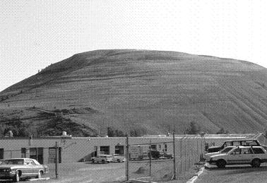
hillshorelines.jpg


Figure 2. Multiple shorelines of ancient Glacial Lake Missoula are emphasized by horizontal shadows high up the side of Mt Jumbo.

Controversial history
The concept of the Lake Missoula Flood has had a controversial history. Based on geological observations back in 1923, J. Harlen Bretz postulated a gigantic flood in eastern Washington from an unknown source.9,10 This started a storm of controversy that lasted about 40 years. The idea of the Lake Missoula Flood was rejected because it seemed too close to the biblical Flood. Victor Baker states:

‘Bretz’ flood theory was so despicable that even circular reasoning could be employed to erect an alternative hypothesis. … One cannot but be amazed at the spectacle of otherwise objective scientists twisting hypotheses to give a uniformitarian explanation to the Channeled Scabland. Undoubtedly these men thought they were upholding the very framework of geology as it had been established in the writings of Hutton, Lyell, and Agassiz.’ 11


The highlight is mine and explains why it is so controversial.
 

Corvus

Feathered eyeball connoisseur
There is no scientific evidence for a global flood, none at all, this line of debate is absurd.

There is plenty against it. However.
 

Kenny

Face to face with my Father
Premium Member
Looking at all the associated nonsense, especially, such as Noah's 450ft long wooden boat that housed all 6.5 million + reproducing pairs of terrestrial animal species. I don't know how you can type it all with no sense of embarrassment.

Problems with a Global Flood, 2nd edition
Because you approach it looking for why it is wrong and read into it to make it wrong and take the information that is anti-creation.
 
Top